
 On eBay Now...
ZL180 Handheld GPS for Surveying, High Precision Rugged Land Surveying Equipment For Sale
When you click on links to various merchants on this site and make a purchase, this can result in this site earning a commission. Affiliate programs and affiliations include, but are not limited to, the eBay Partner Network.

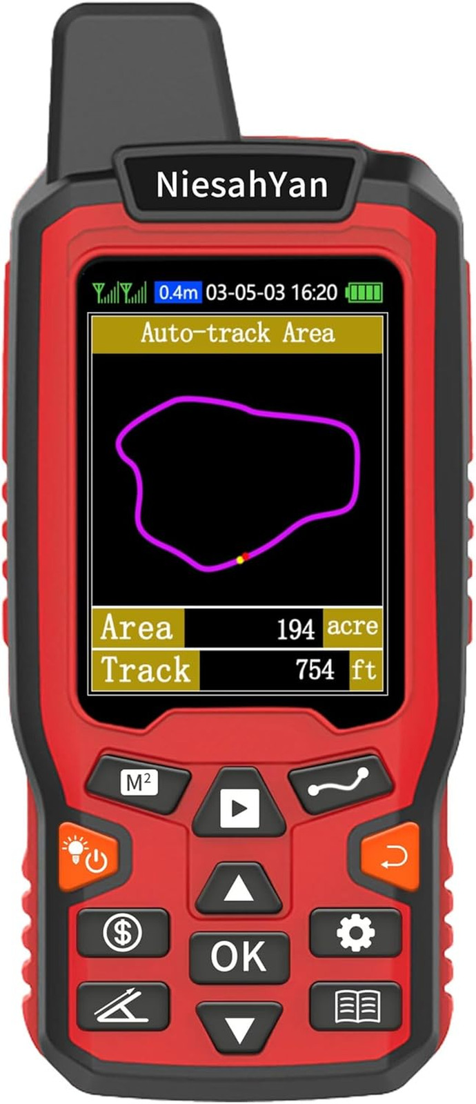
ZL180 Handheld GPS for Surveying, High Precision Rugged Land Surveying Equipment:
$132.29
ZL180 Handheld GPS for Surveying, High Precision Rugged Land Surveying Equipment for Ranches, Garden, Farmland and Parking Area Distance MeasuringDescription Item model number ZL180 Display Type LCD Operating System Windows Mounting Type Handheld Touch Screen Type Capacitive Screen Size 2.4 Inches Product Dimensions 5.5 x 2.3 x 1.1 inches Batteries 1 C batteries required. (included) Item Weight 10.8 ounces Connectivity Technology USB Special Feature Waterproof Map Type Topographical Included Components GPS, Sensor - HIGH PRECISION ACCURACY: 2 high sensitivity satellites global GPS + GLONASS coverage for reliable surveying around the world, support for fast positioning and a reliable signal,area measurement error in 0.003 acres,it cannot be used for saving waypoints and navigation
- LARGE LCD: Our Product has a 2.4 inch FSTN panel and equipped with LCD backlight display, the measurement results can be displayed on the screen directly, convenient for observation
- RUGGED DESIGN: Our Product has a weight of approximately 180g/6.3oz and is compact, making it easy to carry. Adopts humanized groove design, easy to hold and not easy to fall off when using
- 4 IN 1 MEASUREMENT: 2 types of area measurement methods that can measure garden parking lot ranch and flat field.2 distance measurement that can measure straight and curve line distance
- !!! PLEASE NOTE:Please search satellite signals in an open outdoor area before using this device and there is no signal can be found indoors.When the signal value in the upper left corner of the device screen is below 1 m, start measuring to ensure the accuracy of this device
- TIPS: Recommended to measure an area above 0.16 acres and distance above 328 ft. The larger the measurement range, the smaller the error.The device needed to be held horizontal when measuring
- NOTE:The altitude data displayed on the device is GPS altitude, and it changes with Satellite Signal.This is normal!This device only be used for surveying land and cannot be used for saving waypoint and navigation
Product description The video showcases the product in use.The video guides you through product setup.The video compares multiple products.The video shows the product being unpacked. ZL180 Operation Video Merchant Video
Please search satellite signals in an open outdoor area before using this device and there is no signal can be found indoors.
-
What should be caution before using this device?
1. Please search satellite signals in open outdoor area before using the device.No satellite signals can be found indoors.
2. When the signal value in the upper left corner of the device screen is below 1 m, start measure ensure the accuracy of it.
-
What is the range of measurement for this device?
Recommended to measure Area: above 0.16 acres Distance: above 328 ft.The larger the measurement range, the smaller the error.And the precision of this device is within 6ft.
-
What is this device used for?
This device can only be used to measure area and distance. The latitude and longitude and altitude data displayed on the device can only be used as a reference and cannot be saved.
-
Is this device with maps and used for navigation?
No,This device does not have a map function and cannot for navigation.
-
Is the altitude displayed on the device accurate?
No,the altitude is just for reference.And the altitude data displayed on the device is GPS altitude, and it changes with Satellite Signal.This is normal.
ZL180 Handheld GPS for Surveying, High Precision Rugged Land Surveying Equipment
$130.62
ZL180 Handheld GPS for Surveying, High Precision Rugged Land Surveying Equipment
$128.75
ZL180 Handheld GPS for Surveying, High Precision Rugged Land Surveying Equipment
$132.29

Popular Tutorials
Alarms and Indicator Circuit diagrams- Power supply failure alarm
- Theft preventer alarm
- Rain Alarm
- A simple electronic buzzer
- Water Level Indicator with alarm
- Stereo Channel Selector
- Low cost intercom using transistors
- Infrared Head Phones
- Use the CD-ROM drive as a audio CD player without the computer
- Audio Visual Indicator for Telephones
- Ultrasonic pest repellent
- Charge Monitor for 12V lead acid battery.
- Wiper Speed Control
- Dome Light Dimmer for Cars
- Car anti theft wireless alarm.
- Control electrical appliances using PC
- Simple Analog to Digital Converter
- PC based Frequency Meter
- 7 segment rolling display using PC
- Electronic Scoring Game
- JAM(Just A Minute) Circuit
- Flashy Christmas Lights
- TV remote control blocker
- Light Flasher (blinking lights)
- Automatic Dual output Display
- Emergency Light
- Automatic Room Lights
- Running Message Display
- Automatic Speed Controller for fans & Coolers
- Soft Button type Motor Direction Controller
- Super simple stepper motor controller
- Discrete component motor direction controller
- Negative supply from single positive supply
- Self switching Power Supply
- Ultra low drop linear voltage regulator
- Car anti theft wireless alarm.
- Long range FM transmitter
- Remote control using VHF modules
- 40 meter Direct Conversion Receiver
- Remote control using VHF modules
- Remote control using telephone
- A simple Remote control Tester
- Clap Activated Remote
- Radio Remote Control using DTMF
- Ultrasonic switch
- Magnetic proximity sensors
- Dew sensor
- Color Sensor
- Metal Detector
- Optical toggle switch using a single Chip
- Telephone Ringer using 556 dual timers
- Two line intercom plus a telephone changeover switch
- Telephone line based audio muting and light on circuit
- Having secrecy in parallel telephones
- Telephone call meter using calculator & COB
- High Resistance Voltmeter
- A simple Remote control Tester
- Contactless Mains Voltage Indicator
- Zener Diode Tester